METEOROLOGY. - The etymology of the word indicates that originally it referred to the study, or at least the observation, of all supraterrestrial phenomena (τὰ μενέωρα = the things above the earth) which at the beginning of every civilization were considered the expression of one or more divinities depending on the time, the place and the phenomenon. At present meteorology properly so called studies almost exclusively the lower layers of the atmosphere, from the ground up to about 25-30 km. in height and in particular the first 10-15 km.
In this layer, whose thickness is barely a few thousandths of the earth's radius, by means of a very dense network of meteorological stations, whose service is standardized on an international basis, the horizontal and vertical motions of air masses (winds), the distribution of pressure, temperature and water-vapor content, as well as the variations of these quantities, are followed over the entire surface of the earth; and the phenomena relating to the condensation of vapor are observed: fogs, clouds, precipitations of various magnitude and nature.
The messages relating to such observations, condensed into a few coded groups, are transmitted, for the most part by radio, to national and international collecting and retransmitting centers, in such a way that the study centers may have all the observations, plotted with appropriate symbols on synoptic charts, within the two hours following those of observation (1, 4, 7, 10, 13, 16, 19, 22 T. M. E. C.).
Only in this way is it possible to follow as a whole the unfolding of the phenomena of the atmosphere, for the most part very complex and on an intercontinental scale.
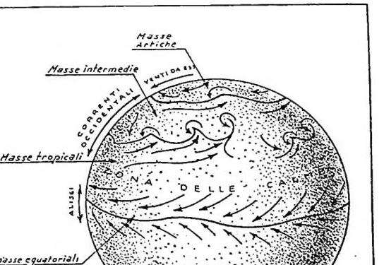
The observations, studied by means of synoptic cartographic elaboration and by statistical methods, have shown how in the atmosphere there exists a kind of "mean general circulation" of a zonal character, that is, along the parallels, and how the great meteorological phenomena may be considered more or less deep perturbations of this circulation. This circulation, roughly symmetrical with respect to the equatorial plane, consists predominantly of currents from East to West at high latitudes (above 60°); of currents predominantly from West to East (westerly currents) at latitudes comprised on average between 60° and 30°; of a zone of subtropical calms between 30° and 15° and finally of a zone of currents from East to West (the trade winds) over the equatorial belt. Particularly interesting is the fact that the westerly currents at an altitude of ca. 10 km. and at a latitude of ca. 45° present a very pronounced maximum (with speeds up to 300 km/h), called the "jet" current.
This mean circulation, attributable, broadly speaking, to the combined effect of the rotation of the earth and of the different solar radiation received by the earth itself at the various latitudes, causes the air masses to remain relatively long at the same latitude, assuming at the various altitudes temperatures and vapor contents that characterize them, so that one may speak, within certain limits, unfortunately rather broad, of arctic air masses (easterly winds), intermediate and tropical (westerly winds) and equatorial (easterly currents: trade winds). These masses then present further particular characteristics (maritime, continental), depending on the geographical support on which they have come to find themselves at the latitude of origin. The air masses preserve more or less long, even through the vicissitudes of a perturbation, the characteristics of the zone of origin, so that, within certain limits, it is possible to recognize them. This is because, as the observations have shown, the air masses that come to move in contact with one another manifest phenomena of mixing that are for the most part quite slight and very slow, so much so that one may speak of a surface of separation between the masses or of a "discontinuity." These surfaces of separation turn out for the most part almost horizontal (inclination from 1 to 10%); and they may undergo wave motions with waves, in which the motion of the particles is predominantly horizontal, which have lengths of the order of a thousand kilometers and which, under conditions of instability of the two air masses between which they form, may evolve to the point of forming those gigantic vortices with a vertical axis that constitute the cyclones, in which the potential energy of the air masses in contact (the cold, denser ones descend, the warm ones rise) comes to be transformed into energy of motion (wind).
The phenomena of condensation (clouds, rains, etc.) that precede or accompany in every case the abrupt variations of temperature and wind, are precisely due to the passage over the zone concerned of a discontinuity between two different air masses and under conditions of instability. It is the warm masses that, rising above the cold ones and being raised by those cold ones (and the phenomenon may be accentuated or attenuated by the orography or by other causes), pass from high pressure (at the ground) to low pressure (at altitude); they thus undergo a process of expansion that is approximately adiabatic, that is, without exchange of heat with other masses, and therefore they cool down, reaching saturation (at the altitude where the base of the clouds will come to be) and condensing the vapor contained into droplets or ice crystals.
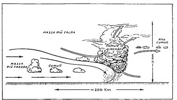
The surfaces of discontinuity, at which the warm air comes to overlie the cold masses, are called warm discontinuities, and their intersection with the ground is called the warm front; on average they present this succession of clouds: "cirri" constituted by ice crystals, very white, tenuous and transparent and at an altitude of around 6-8 km.; "altostrati" of droplets below zero, but liquid; they are white and denser than the former and at an altitude between 2 and 6 km.; "nembostrati," of relatively large water droplets, darkening and with a base that may even be very low, of great thickness (2-5 km.) which give continuous precipitations (rains, snow); below them there are often banks of continuous or fragmented clouds (strati, fractostrati) or fogs. The surfaces of discontinuity, at which the warm air is raised by the cold, are called cold discontinuities, and their intersection with the ground is called the cold front; on average they present this succession of clouds: "altocumuli," constituted by water droplets, white, in more or less large aggregates (known by the popular name of fleecy clouds) at an altitude between 2 and 6 km.; "cumulonembi," typical storm clouds with very high whitening summits (6-8-10 km.), constituted by ice crystals and by dense darkening bodies, formed by water droplets that at the base, often very low, are very large; they are accompanied by shower precipitations, in particular by hail, and these are followed by "cumuli" or "imposing cumuli" with their base at a kilometer and summits from 2 to 5 km.
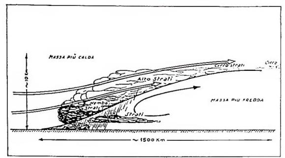
The passage of a warm discontinuity lasts on average a day, that of a cold one a few hours. In reality nature often departs from this very simple scheme; indeed cold and warm discontinuities may join and overlap in mixed systems called "occlusions," but it is above all the orographic obstacles, the warm and cold seas, etc. that may bring about even very deep alterations in the evolution of a system of discontinuities, both from the dynamic and from the thermal point of view, strengthening or attenuating the frontal phenomena in intervals of time that are at times very brief. This is what determines the difficulties encountered by forecasting meteorologists, difficulties all the greater the more tormented the geography of the zone studied, as in particular happens for the Mediterranean zone (v.: ORGANIZZAZIONE METEOROLOGICA).
Bibliography7 works
Giorgio Fea