
METEREOLOGIA. – The etymology of the word indicates that originally it referred to the study, or at least the observation, of all superterrestrial phenomena (τὰ μενέωρα = things above the earth), which at the beginning of every civilization were considered expressions of one or more divinities, depending on the time, place, and phenomenon. At present, m. properly speaking studies almost exclusively the lower layers of the atmosphere, from the ground up to approximately 25–30 km. in altitude, and in particular the first 10–15 km.
Within this layer, whose thickness is only a few thousandths of the Earth’s radius, a very dense network of meteorological stations, whose service is standardized on an international basis, monitors over the entire surface of the earth the horizontal and vertical movements of air masses (winds), the distribution of pressure, temperature, and water-vapor content, as well as variations in these quantities; and phenomena relating to the condensation of vapor are observed: fog, clouds, and precipitation of varying intensity and nature.
Messages concerning these observations, condensed into a few coded groups, are transmitted, mostly by radio, to national and international collection and retransmission centers, so that study centers may have all the observations, represented by suitable symbols on synoptic charts, within the two hours following the time of observation (1, 4, 7, 10, 13, 16, 19, 22 T. M. E. C.).
Only in this way is it possible to follow as a whole the development of atmospheric phenomena, which are for the most part highly complex and occur on an intercontinental scale.
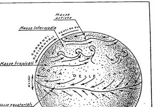
The observations, studied through synoptic cartographic processing and statistical methods, have shown that there exists in the atmosphere a kind of «mean general circulation» of a zonal character, that is, following the parallels, and that the great meteorological phenomena may be regarded as more or less profound disturbances of this circulation. This circulation, roughly symmetrical with respect to the equatorial plane, consists predominantly of currents from East to West at high latitudes (above 60°); of currents predominantly from West to East (westerlies) at latitudes lying, on average, between 60° and 30°; of a zone of subtropical calms between 30° and 15°; and finally of a zone of currents from East to West (the trade winds) in the equatorial belt. Particularly interesting is the fact that the westerlies at an altitude of approximately 10 km. and at a latitude of approximately 45° display a very pronounced maximum (with winds reaching 300 km/h), known as the «jet» stream.
This mean circulation, attributable in broad terms to the combined effect of the Earth’s rotation and the differing solar radiation received by the Earth itself at various latitudes, causes air masses to remain relatively long at the same latitude, acquiring at various altitudes the temperatures and vapor contents that characterize them. Thus, within certain unfortunately rather broad limits, one may speak of arctic (easterly winds), intermediate and tropical (westerly winds), and equatorial (easterly currents: trade winds) air masses. These masses subsequently acquire further particular characteristics (maritime, continental), depending on the geographical surface over which they have come to lie at their latitude of origin. Air masses retain, for a more or less long period, even through the vicissitudes of a disturbance, the characteristics of their zone of origin, so that, within certain limits, it is possible to recognize them. This is because, as observations have shown, air masses that come to move in contact with one another exhibit mixing phenomena that are generally very slight and very slow, so much so that one may speak of a surface of separation between the masses, or of a «discontinuity». These surfaces of separation are generally almost horizontal (inclination from 1 to 10%); and they may undergo undulatory movements, with waves in which the motion of the particles is predominantly horizontal, having wavelengths on the order of a thousand kilometers and which, under conditions of instability of the two air masses between which they form, may develop into those gigantic vortices with a vertical axis that constitute cyclones. In these, the potential energy of the contacting air masses (the colder, denser ones descend, while the warmer ones rise) is transformed into kinetic energy (wind).
The condensation phenomena (clouds, rain, etc.) that in every case precede or accompany abrupt variations in temperature and wind are precisely due to the passage, over the area concerned, of a discontinuity between two different air masses under unstable conditions. It is the warm masses that, rising above the cold ones and being lifted by them (and the phenomenon may be intensified or attenuated by orography or other causes), move from high pressure (at the ground) to low pressure (at altitude); they thus undergo an approximately adiabatic expansion process, that is, without an exchange of heat with other masses, and consequently cool, reaching saturation (at the altitude where the cloud base will be located) and condensing the vapor they contain into droplets or ice crystals.
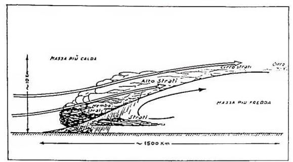
(courtesy of Dr G. Fea) METEOROLOGIA - Diagram of a typical warm front.
The passage of a warm discontinuity lasts on average one day, while that of a cold one lasts a few hours. In reality, nature often departs from this simple pattern; cold and warm discontinuities may already join and overlap in mixed systems called “occlusions,” but it is above all orographic obstacles, warm and cold seas, etc., that can produce even profound alterations in the evolution of a discontinuity system, both dynamically and thermally, strengthening or attenuating frontal phenomena over sometimes very short periods. This is what causes the difficulties encountered by weather forecasters, difficulties that are all the greater the more complex the geography of the area under study, as occurs especially in the Mediterranean region (v. : ORGANIZZAZIONE METEOROLOGICA).