Machine translation of the 1948–1954 Italian original. The original text is authoritative.
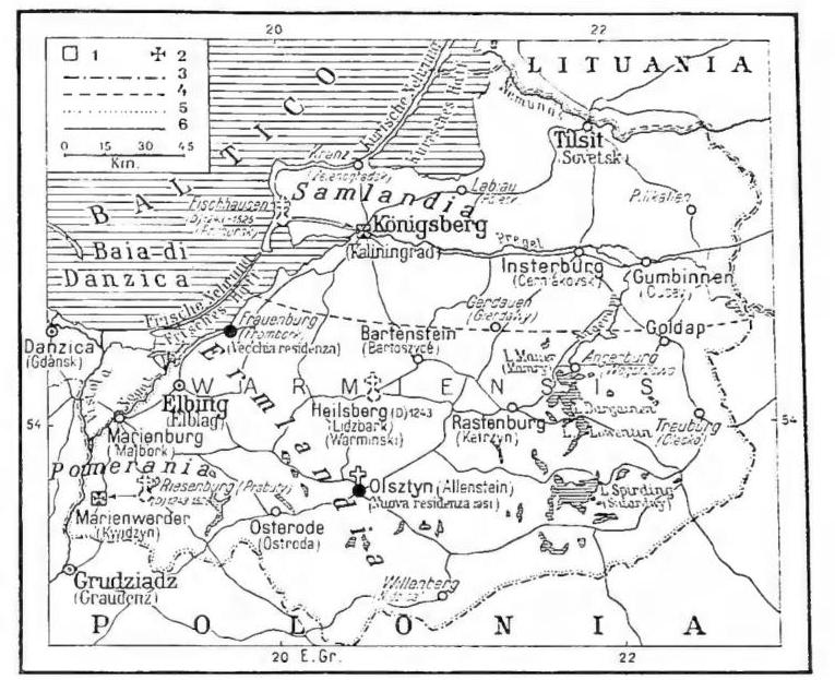
EAST PRUSSIA. - GEOGRAPHY. - By this name (Ost-Preussen), in German tradition (E. P. passed to Germany in 1618), was meant the northeastern extremity of the territory of the Reich, between Lithuania, Mazovia and West Prussia.
Toward the latter region the border ran, before 1918, from the Frisches Haff to Soldau, keeping somewhat east of the lower Vistula. After the First World War, when the Republic of Poland was created (28 June 1919), the so-called Polish Corridor, which reached Danzig, isolated E. P. from the rest of Germany; E. P. terminated to the west at the Vistula, but had been mutilated by the removal of the Memel district (annexed to Lithuania). Within these limits E. P. covered 36,991 sq. km., with a population, in 1939, of 2.4 million inhabitants (65 per sq. km.). It was an almost entirely flat territory, or one with gentle hilly undulations (at most only slightly exceeding 300 m.), in whose undulations numerous lakes, ponds and peat bogs were situated; it opened onto the Baltic with a low coast fringed by long sandy bars (Ger. Nehrung, Pol. Mierzeja). Once almost entirely covered with forests (now reduced to barely one-sixth of the total area), E. P. had been transformed by German colonization (dating back to the 13th century) into an agricultural region which, although not wholly fertile, produced considerable quantities of grain, as well as potatoes, sugar beets and vegetables. Livestock breeding (cattle and horses) was also well developed there. In the population, the German element was distinguished from the Masurians, of Slavic stock (just over 120,000, predominant in the inland regions), although the latter too had by then become profoundly Germanized; above all, the larger population centers (with the capital Königsberg, which exceeded 100,000 inhabitants) had assumed a typically German appearance.
Under the Potsdam agreements and the Treaty of 16 August 1945 between Poland and the U.S.S.R., E. P. was divided into two parts: the southern part (Masuria), incorporated into the new Republic of Poland, in which it essentially constituted the voivodeship of Olsztyn (Allenstein; 20,994 sq. km. with 442,000 inhabitants); the southern part an-
annexed to the U.S.S.R. as the autonomous district of Kaliningrad (Königsberg; 10,000 sq. km. with 400,000 inhabitants), dependent on the R.S.F.S.R. The frontier between the two units runs approximately along 54° 20' N.
BIBL.: F. Mager, Ostpreussen, Hamburg 1922; anon., Ostpreussen, Land und Leute in Wort und Bild, Königsberg 1926; M. Friederichsen, Ostpreussen, Berlin 1928. Giuseppe Caraci
HISTORY. - The name of EAST PRUSSIA (P. O.), rather than designating a geographical unit, is a historical-political definition and dates back to 1772, when, after the first partition of Poland, Frederick II of Prussia obtained Pomerelia, to which he gave the name of WEST PRUSSIA. The territories of the former Duchy of Prussia, the political center of the state established by the Teutonic Order in the Middle Ages, located east of West Prussia, thus received the name of EAST PRUSSIA.
After the migrations of the Germanic peoples toward the West, present-day East Prussia was inhabited by a Baltic population, the Prussians, pagan and of a highly warlike nature; attempts were made to convert them to Christianity, but both Adalbert of Prague and Bruno of Querfurt, who around the year 1000 undertook this mission, met violent deaths and suffered martyrdom. Subsequently, the kings of Poland also endeavored to subdue the Prussians, but without success. More concrete results were achieved by the evangelizing mission, initiated around the early years of the 13th century by the Cistercian monk Christian, who in 1216 was consecrated Bishop of Prussia. However, as the hostility of the Prussians increased, Duke Conrad of Masovia turned around 1226 to the Teutonic Order for assistance. To enable the Order to subdue the infidels, Duke Conrad donated the Culmerland (Terra Colmensis: German Kulm, Polish Chełmno), likely as an operational base for the crusade against the Prussians, to the Grand Master of the Order, Hermann von Salza. The intervention of the Order led in a very short time to the conquest
(from G. Hauptmann, Deutschland, Berlin 1938, pl. 292)
EASTERN PRUSSIA - Granaries of Königsberg.
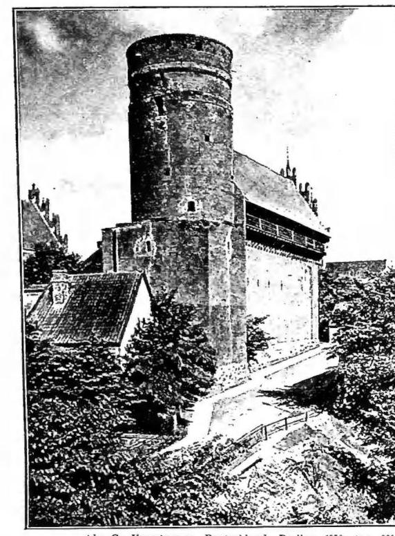
(from G. Hauptmann, Deutschland, Berlin 1938, pl. 885) EAST PRUSSIA - Ancient castle of the Teutonic Order. Allenstein.and the Christianization of E. P., and Innocent IV, around the mid-13th century, divided the territory into the four dioceses of Kulm, Pomesania, Sambia, and Varmia. The Christianization of the territory was almost immediately followed by the Germanization of E. P. and the majority of the Baltic countries. The Order became the predominant power in that region of Europe, and its hegemony was broken only in 1410, with the Battle of Tannenberg won by the Poles. In 1466, with the Peace of Toruń, concluded with Casimir IV, the Order finally lost its independence as well, and the Grand Master became a vassal of the Polish Crown. In 1525, the Grand Master of the Order, Albrecht of Brandenburg-Ansbach, converted to Lutheranism, secularized the Order's possessions, which from then on were transmissible both directly and indirectly, and assumed the title of duke under the high sovereignty of the King of Poland. The bishops of Pomesania and Sambia also abjured the Catholic faith, but not those of Kulm and Varmia. In 1562, Sigismund Augustus, King of Poland, recognized the right of succession to the duchy of P. for the Elector of Brandenburg and his successors, in the event that that line of the house became extinct. After the death of the last duke, Albrecht Friedrich, the Elector George William indeed paid homage in 1621 to Sigismund III as Duke of P. E. P. was released from all ties to the Polish Crown with the Treaty of Wehlau (1675), when John Casimir recognized the full sovereignty of the Elector Frederick William over II. From then on, E. P. was an integral part of the Kingdom of Prussia, established in 1701, and after the end of the First World War, of the Prussian Land. The Potsdam Agreement of 2 August 1945, pending the definitive peace treaty with Germany, granted Poland the administration of all former German territories east of the Oder-Neisse line, including therefore E. P. Instead, the annexation of the city of Königsberg, renamed Kaliningrad in 1946, and the adjacent territory to Russia was recognized.
BIBL.: K. Lohmeyer, Gesch. von Ost- und Westpreussen, I (up to 1411), 3ª ed., Gotha 1908; E. Caspar, Hermann von Salza und die Gründung des Deutschordentates in Preussen, Tubinga 1924; C. Krollmann, Die Bestellung Ostpreussens durch den Deutschen Orden, in Vierteljahrsher. für Sozial- und Wirtschaftsgesch., 21 (1928), pp. 280-98; A. Uckley, Ostpreussen, in Die Religion in Gesch. und Gegenwart, IV, 2ª ed., Tubinga 1930, coll. 830-36, with bibl.; E. Vermecke, Bibliogr. der Gesch. von Ost- und Westpreussen, Königsberg 1932-33; M. Hein, Ostpreussen, in A. Brackmann, Deutschland und Polen, Monaco-Berlino 1933, pp. 123-34; E. E. Stengel, Hochmeister und Reich. Die Grundlagen der staatsrechtl. Stellung des Deutschordens, in Zeitschr. der Savigny-Stiftung, Germ. Abt., 58 (1938), p. 178 ff.; The Cambridge Hist. of Poland, I, Cambridge 1950, passim. Silvio Furlani
Cite this article
“PRUSSIA ORIENTALE.” Enciclopedia Cattolica, vol. X (1953), p. 151. Azione Romana digital edition, https://azioneromana.com/article/prussia-orientale.