
ITHAMAR (Hebr.: 'Ithamār) – The last son of Aaron (Ex. 6:23); consecrated as a priest together with his brothers and Aaron (Ex. 28:1, 4, 29); he supervised the making of the sacred furnishings (Ex. 38:21). After Nadab and Abihu were struck down for their ritual offense, Eleazar and I. assumed all the priestly functions (Lev. 10; Num. 3:1-4; 26:60).
I. presided over the Gershonites and the Merarites for the transport of certain parts of the Tabernacle in the desert (Num. 4:28, 33; 7:8). The descendants of I. (the family of Eli) had custody of the ark at Shiloh (I Sam. 1). Under David, they performed the priestly functions together with the descendants of Eleazar (the family of Zadok) (I Par. 15:11 ff.; 16:37-43). The latter, who were also greater in number (I Par. 24:1-18), prevailed, particularly from the time of Solomon, who exiled Abiathar and gave the high priesthood to Zadok (I Reg. 2:26 f.). This predominance became exclusive after the exile (cf. Ez. 40:46; 44:15 f.). Among those who returned with Ezra was a Daniel, descendant of I. (Ead. 8:2).
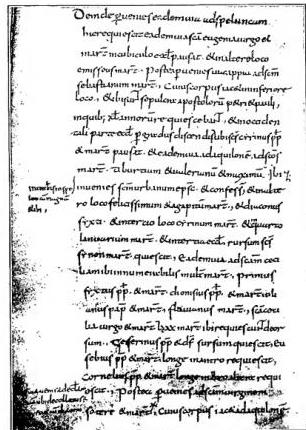
ITINERARIES — Notitia ecclesiarum Urbis Romar; description of the sanctuaries along the Latina and Appian Ways — Vienna, National Library, cod. 795, formerly Salzburg 140, fol. 185r (end of the eighth century).
They serve very diverse purposes: military, commercial, utilitarian. They develop and improve with the expansion of a nation. The conquests of Alexander and those of the Romans bequeathed to future generations an entire network of roads, first traversed by phalanxes and legions, then by merchants, traders, emigrants, and pilgrims, driven by the desire for gain, by the pressure of other peoples, by religious sentiment, or by other motives. The road from Babylonia to Pontus became well known after the anabasis and catabasis of the soldiers led by Xenophon, just as the Roman conquests established a sure knowledge of the passability of the roads, the nature of the routes, and the measurement of distances. Transport services were then organized, giving rise to the travel guides that have come down to us.
I. ROMAN ITINERARIES
These are itineraries engraved on silver vessels, such as those of Vicarello, or inscribed on the marble of milestone stones, such as those of Tongres or Autun, or reproduced on clay tablets, as on every other writing material. From an examination of these itineraries one may infer that, at a certain period, they became standardized for the use of every purchaser: a complete indication of the distance in miles from the point of departure to the destination (Cadice-Roma; Santiago di Compostella-Roma), followed, in spatial succession, by the intermediate mutationes and stationes, with their respective distances.Among the numerous itineraries bequeathed to us by the Latin world are the two Itineraria Antonini Augusti: one concerning the provinces, the other concerning ports and landing places for navigators. In each, distances are measured in miles; and anyone familiar with manuscripts will not be surprised that the figures given must be treated with great distrust. The itineraries cited follow one another without order, and the whole document, far from representing an official compilation, appears to have been drawn up by a private compiler from a mappa mundi, according to the criterion of bringing together, around a centre of radiation, the minor itineraries connected with II.
Mention has been made of the Mappae mundi. It is known that during the Empire, when few corners of the world did not feel Roman hegemony, the Romans displayed in porticoes coloured geographical maps, depicting the Empire and indicating locorum situs, spatia, intervalla. From these coloured mappae derive the itineraries of the tabula Peutingeriana type, the itineraries of the Anonymous Ravennate, and the Geographica of Guido da Pisa.
The first, which takes its name from its owner, C. Peutinger, consists of a parchment roll, now in the
Biblioteca di Vienna, where it has been divided into its eleven constituent skins. It seems possible that it goes back to an exemplar of the 3rd century. Prominently displayed, marked in red, is a road map, with the spatial indications characteristic of all itineraries; but here the draughtsman uses symbols to indicate cities or other features.
The Anonymous Ravennate compiled his Cosmographia around the 8th century, having before him an equal number of maps drawn by different cosmographers. He is
a monk, describing the world to a fellow monk; and, since he found the maps discordant with one another, he follows the better-informed cartographers, giving precedence to natives of the region depicted. For each region, its cities, rivers, and lakes are recorded; this is followed by a list of islands, arranged according to the continents to which they belong. He warns his fellow monk not to be surprised if civitates vel flumina nuper aliter appellentur, because of the migrations of peoples that had occurred; whence it follows that the source-maps had been compiled before the barbarian invasions.
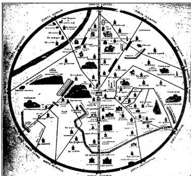
ITINERARIES — Plan of Rome at the end of the eighth century, reconstructed on the basis of the Einsiedeln Itinerary.
Guido Pisano, dating from the twelfth century, when geographical studies were acknowledged to have social importance, writes in humanae vitae communione, so that man may know how to live non sibi soli, sed aliis vivere. He focuses especially on Italy and the Mediterranean regions, as far as the western borders of Spain and the northern borders of England.
II. THE
I. OF THE HOLY LAND
From the earliest Christian generations, there was a desire to visit the places that bore witness to biblical and especially Gospel events. Eusebius’s Ecclesiastical History (PG 20, 396 and 542) presents various pilgrims, such as Melito of Sardis (ca. 170) and St. Alexander of Cappadocia (3rd cent.), who had already come to Palestine during the period of the persecutions. The pilgrimage movement naturally intensified with the Edict of Toleration, and it has always remained alive, even though at certain times it was obstructed by the Arabs. The pilgrims made known in Europe the existence of the Sanctuaries and the condition in which they were found, brought back relics from them, sought to reproduce them in their own countries, and contributed to the development of certain devotions such Way of the Cross (v.). The writings of the pilgrims, called i., are often of considerable importance for gaining knowledge of biblical (v. ARCHEOLOGIA BIBLICA) and Christian traditions and of the condition of the Sanctuaries, because they are frequently the only testimonies on the subject. The number of surviving i. is enormous, so that it is possible to enumerate only a few of the principal ones.In the 4th cent., the Itinerarium
Burdigalense is of particular importance. It is regarded as an ordinary guide for a Bordeaux–Jerusalem journey, compiled by or for a merchant or pilgrim, Jewish or Christian, around 333. The indications are those of a normal i., but here a historical memory is attached to the name of a city, and these references become more frequent upon reaching Palestine. At this point the Christian material becomes abundant, and the i. changes into a summary description of the Holy Places. Around 390 St. Jerome translated into Latin a short work by Eusebius of Caesarea, Hebraicorum nominum, which enjoyed wide success. Jerome himself, in a letter to Eustochium, expressed amazement that Palestine should not arouse greater interest in Christian hearts than the Tarpeian Rock; and he invited the noble Marcella to come to the East to see the places where our religion was born (Ep.
ad Paulam et Eustochium).
The first account of a journey to the East is connected with the name of Etheria, Egeria (v.), a vivid and animated narrative covering Palestine, Egypt, and Mesopotamia.
Practically negligible, on the other hand, is the letter attributed to Eucherius of Lyons and addressed to the presbyter Faustus: a patchwork drawn from St. Jerome and Hegesippus. The author lacks any direct knowledge of the places described. Nor does the De situ Terrae Sanctae, compiled by a North African, Theodosius, around 530, appear to deserve a better assessment. Much more important, even though it incorporates popular narratives and legends, is the i. falsely attributed to St. Antoninus, martyr of Piacenza. The writing is packed with important information, deriving from one of the martyr’s travelling companions. The account, dictated from direct impressions, was written around 570.
(phot. Enc. Catt.)
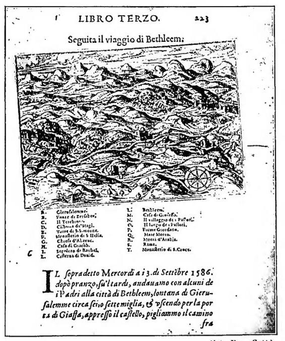
ITINERARIES – Bethlehem with an indication of its monuments.
Engraving by Natale Bonifacio Dalmata (1586), reproduced in:
Giovanni Zuallardo, Il devotissimo viaggio di Gerusalemme.
Rome 1587, p. 223 – Copy in the Vatican Library.
Precisely a century later Adamnan of Hy (623–704) wrote the De Locis Sanctis libri tres, based on the oral accounts of the Frankish bishop Arculf, an astute observer and scrupulous narrator of what he had seen during a nine-month pilgrimage. Adamnan is a diligent and meticulous compiler, and his account arouses keen interest. Bede is merely a compiler of Adamnan, Pseudo-Eucherius, and others. Between 727 and 720, St Willibrord related to a nun of Heidenheim, who recorded them, his impressions of a journey he had made many years earlier. Some imprecision in the account should be attributed, rather than to negligence on the part of the recorder, to the narrator’s faded memory. The nun participates so vividly in the account that, in evoking it and feeling almost like its protagonist, she inadvertently passes from the third person to the first: the text constitutes a noteworthy supplement to the Arculf–Adamnan narrative.
The i. of Epiphanius Agiopolite, on the other hand, achieves a notable informative purpose; his account proceeds from direct impressions, “and whoever writes otherwise—for these are his words—deceives himself, ignoring the truth.” Around 867 a French monk, Bernard, having obtained the assent of Nicholas I, set out in the company of an Italian and a Spaniard for the Holy Places. After visiting Palestine, the three returned to Rome by sea, stopping at the Lateran, and bringing their pilgrimage to a close at the sanctuary of St Michael on the Gargano.
The i. examined here repeatedly mention harassment suffered by pilgrims at the hands of officials in charge of crossings or border offices; from the eleventh century onward these journeys, undertaken in isolation, became hazardous: to be more certain of arriving, it was necessary to organize oneself in groups and, when required, to be well armed. The Liber de Locis Sanctis of Pietro Diacono, dedicated to Abbot Wibald of Montecassino, did not, however, arise from such pilgrimages. It is a compilation assembled around 1137 from Bede’s work of the same name and the Peregrinatio Aetheriae, which can be supplemented, in its missing opening section, precisely by these excerpts reported by Pietro Diacono.
Around 1165, Giovanni of Würzburg set out to describe the state of Jerusalem as it appeared to him after the devastation it had recently suffered. He reproduces the metrical and prose inscriptions displayed on the various monuments. Another who kept his eye on the actual state of the Holy City was Giovanni Foca, who left a description of it in Greek in 1177.
A brief mention should be made of the i. of Beniamino of Tudela, a Jew from Navarre who visited the whole of the East as far as the borders of China during a journey lasting thirteen years. His account, translated into various languages, constitutes an important source for the history of the Jews in the twelfth century.
In the post-Crusade period, the i. BURCARDO II (v.), with sound geographical knowledge, Ricoldo of S. Croce, Pipino, and P. Faber (1480–83), Dominicans, should be noted, as well as those of Giacomo da Verona (1335), an Augustinian, A. De Reboldi (1327 and 1330), Niccolò da Poggibonsi (v.), the first, so far as is known, to write in Italian, F. Suriano (v.), Bonifacio da Ragusa, and above all F. Quaresmio (v.) of the Franciscans. Since Fr. Quaresmio made an exhaustive study of the traditions, the i. that follow, from this point of view, do no more than connect with his work.
From a literary and historical point of view, those of Mariti (1767), Chateaubriand (1806), Bassi (1846), Cassini da Perinaldo (1846), Matilde Serao (1893), E. Battaglia (1906), and the more recent ones by G. Venturini, S. D’Amico, C. Angelini, and M. Sticco should be remembered. From an illustrative point of view, mention should be made of the woodcuts in von Breitenbach’s i. (1483), the freehand drawings of Zuallardo (1586), those drawn to scale by B. Amico (v.), and the beautiful views by C. Le Bruyn (1714).
III. THE
I. OF THE CITY OF ROME
The cult of the apostles Peter and Paul, as well as of the martyrs, intensified and grew stronger with the persecutions: after the conversion of the various European peoples to Christianity, vivere peregrinando came to be regarded as one of the most meritorious means of obtaining indulgences; hence there was a greater frequency ad limina Apostolorum.Once the pilgrimage to Rome had begun, the vastness of the Urbs and the dispersal of the Christian monuments obliged the visitor, who had to perform his acts of devotion, to procure guides, almost internal itineraries, which would point out the places to be visited.
The Notitia and the Curiosum were once regarded as itineraries of this kind, dating from before Constantine. But if those documents are stripped of the additions introduced into them by centuries of elaboration and by anonymous collaboration—which, having lost knowledge of their original purpose, sought to reduce them to guides for pilgrims—and if they are restored to their primitive outline, one will easily recognize in them nothing other than a spatial delimitation of the duties of the 48 vicomagistri who, in each of the XIV regions, regulated the life of the city while protecting and safeguarding the interests of the public. But in the first half of the seventh century, according to some, or in the second half of the eighth, according to others, a genuine Roman itinerary for pilgrims is found formulated: Notitia ecclesiarum urbis Romae. The pilgrim sets out from the basilica of SS. Giovanni e Paolo, the only urban church that preserved the bodies of martyrs; from there he passes to the Via Flaminia, then follows the old and new Via Salaria, the Via Nomentana, the Via Latina, the Via Appia, the Via Ardeatina, the Via Ostiense, the Via Aurelia, the Via Portuense, and the Via Cornelia, as far as the tomb of S. Pietro. The principal roads are sometimes abandoned in order to follow side roads; but everywhere the basilicas and the locations of the various hagiographical groups are precisely indicated. The booklet concludes with a detailed description of the Vatican-Constantinian basilica. For De Rossi, the itinerary predates 650. According to Sickel, this itinerary was written in 799 by an unknown author who accompanied Bishop Arnone of Salzburg to Rome.
Slightly later appears another itinerary, the Liber de locis sacris martyrum. Unlike the preceding work, this one begins with S. Pietro and proceeds along the Via Cornelia, the Via Aurelia, the Via Portuense, the Via Ostiense, the Via Ardeatina, the Via Appia, the Via Latina, the Via Labicana, the Via Prenestina, the Via Tiburtina, the Via Nomentana, the new and old Via Salaria, ending at the church of S. Valentino on the Via Flaminia.
To be precise, it is less an itinerary than a notice concerning the churches and tombs situated along each road, to which the indications of proximity or distance, as well as every other spatial indication, refer. The exposition is not always orderly, nor always clear, since the Liber is probably an epitome of a record of martyrs and saints. It is not easy to understand for what purpose a list of the churches within the walls was placed at the end of this itinerary, or according to what criterion it was arranged. In its present form, the itinerary may be assigned to the first thirty years of the seventh century.
Another kind of itinerary, perhaps slightly later, is the one inserted by William of Malmesbury in his Gesta regum Anglorum, with some variations of an indeterminate nature, though attributable solely to the wording. As in the De locis, it also begins at the Vatican and continues, proceeding to the right, in the same direction as the Notitia. There are also references to the tombs of the saints within Rome.
Much more important is the I. Einsiedlense, which should be assigned to the Carolingian age. The author traced II itineraries, extending even beyond the city. The text is based on the principle of giving the pilgrim a clear representation of the spatial relationships among the individual entries. The compiler intended to indicate to the pilgrim, with the greatest realistic precision and tangible clarity, where he would find the monuments to be visited. Having set him on a road, with this kind of guide in hand, the author points out the places to the right and left, and also indicates the distance between individual entries by the position occupied by the names of the individual monuments. This skilful arrangement of the original, once awareness of the person who had devised it had been lost, gradually disintegrated as knowledge of these initial informative principles disappeared, so that later copies, in the most favourable case, were reduced to lists of names placed without any relation of proximity, on the right or left of a given route. Despite the entirely arbitrary conjectures of the critics, who increasingly altered its nature, this precious document remains a witness to the surviving pagan Rome and to the Christian Rome that arose beside it, up to the Carolingian age.
The II itineraries are: from S. Pietro to S. Paolo, from Porta S. Pietro to S. Lucia in Orfea; from Porta S. Pietro to the Via Salaria, from Porta Nomentana to the Roman Forum, from Porta Flaminia to the Via Lateranense, from Porta Tiburtina to the Suburra, from the Via Tiburtina to S. Vito, from Porta Aurelia to the Via Prenestina, from Porta S. Pietro to the Via Asinaria, from the 7 roads to Porta Metronia, from Porta Appia to the Schola graeca and then, along a portico, as far as the aqueduct and along the 7 roads.
The distances could be made evident by the placement of the entries and by the distance separating them on the map. All these itineraries are traced with such precision that it seems entirely possible that the author knew the places de visu and had taken the greatest care in recording them; this conjecture is confirmed by the collection of profane and Christian inscriptions found in the very same Codex Einsiedlensis. The toponyms of the Roman roads and monuments still (in the eighth century) preserved their classical names. Nor did the compiler obtain this information anywhere other than Rome; its extraordinary diffusion should be regarded as proportionate to the influx of pilgrims.
Last in chronological order must be considered the itinerary that the archbishop of Canterbury, Sigeric, left of his journey to Rome, undertaken in 990. It consists of two parts: the first gives the list of the stations (mansiones) on the overland journey from England to Rome; the second is a list of Roman churches visited on different days by Sigeric and his retinue, important for the topography of the churches in question.
After the year 1000, the itineraries took the form of descriptions of monuments accompanied by poetic legends, approaching in a certain way some of the descriptions of the monuments of the Holy Land mentioned above. Their compilation is known under the title Mirabilia, Indulgentiae ecclesiarum urbis Romae. Later, after 1500, came the treatises on scientific topography.
Wilbrandus), Leipzig 1864; T. Tobler, Descriptiones Terrae Sanctae ex suec. VIII, IX, XII, XV, ibid. 1874; T. Tobler – A. Moliner, Itinera Hierosolymitana et descriptiones Terrae Sanctae bellis sacris anteriora, lingua latina exorata, Geneva 1879; H. Michelant – G. Raynaud, Itinéraires à Jérusalem et descriptions de la Terre Salate rédigées en français (XIe, XIIe, XIIIe siècle), ibid. 1882; L. Conrady, Vier rhetorische Palästina-Pilgerstrifilm des XIV., XV. und XVI. Jahrhunderts, Wiesbaden 1882; B. de Khitrow, Itinéraires russes en Orient traduits, Geneva 1889; P. Geyer, Itinera Hierosolymitana sacri III-VIII, in CSEL, 39, Vienna 1898; A. Baumstark, Abendland. Palästinapilser des ersten Jahrtausends u. ihre Berichte, Cologne 1906; A. van de Wyngeert, Sinica Franciscana, Itinera et relationes Fraterna Minorum suec. XIII et XIV, Quarracchi 1920; O. Cuntz, Itineraria Romana, I (Antonini Augusti et Bardigalente), Leipzig 1920; B. Pesci, L'i. romano di Sigerio, uovo. di Canterbury, in Rev. di arch. crist., 13 (1936), pp. 43–60; J. Schnest, Itineraria Romana, II (Ottenentis anonimi cosmographia et Guidonis Geographica), Leipzig 1940; R. Valentini and G. Zucchetti, Codice topografico della città di Roma, II, Rome 1942 (critical annotated edition of the works concerning the city of Rome). For the souvenirs brought back: B. Bagatti, Eulogie palestiniei, in Orientalia Christiana periodica, 15 (1949), pp. 126–66.