
UNITED STATES (U. S. A.). — Confederation of 48 States, one federal district (D. C.), and two territories (Alaska and the Hawaiian Islands), upon which depend, in America, Puerto Rico, the Virgin Islands (Antilles), and the Canal Zone (of Panama), and in Oceania, some of the Samoan Islands and Guam (Marianas), in addition to the Micronesian Islands formerly under Japanese mandate, which the U. S. A. hold under trusteeship.
I. GEOGRAPHY
Even when considered solely in terms of the extent of their metropolitan territory (7,827,076 sq km, including 117,207 sq km of inland waters, but excluding 156,172 sq km belonging to the federal portion of the Great Lakes, which the U.S.A. share with neighboring Canada), the U.S.A. rank among the earth’s major powers. If Alaska (destined to become the 49th State of the Union) is also included, this area rises to 9.5 million sq km (1/16 of the emerged landmass). Bringing together the metropolitan territory and dependencies, the U.S.A. exceed 11 million sq km, but fall to fourth place in the world, after the British Commonwealth, the U.S.S.R., and the French Union, while possessing an area greater than that of all Europe.By virtue of the position of their metropolitan territory, the U.S.A. differ from the other major world powers in being in direct contact with only two other states—the Canada to the N., Mexico to the S. (whose borders are for the most part conventional)—despite the fact that their international stature involves them in the political problems of every corner of the earth. So extensive a territory, occupying by itself more than one-third of the North American continent, and far more than its ecumenical area, cannot fail to display considerable regional differences. In essence, however, its structure is fairly simple: a broad central plain extending from the Great Lakes to the Gulf of Mexico, flanked by two mountainous belts on the W. (Pacific) and the E. (Atlantic), which isolate it from direct oceanic influence. Of the two belts, the eastern one, more slender (the Appalachians or Alleghenies), consisting of a bundle of
The western highlands, incomparably more extensive, consist of at least three ranges of mountains, one of them inland, extending from the Canadian border to the Rio Grande (Rocky Mountains), and two near the Pacific coast, separated from the former by a series of plateaus of differing character (the basaltic tableland of Columbia in the N., the arid one of Colorado in the S., cut by deep cañons, and, between the two, the Great Basin, a vast complex of uplands and basins, dotted with marshes and salt lakes). Despite their height (numerous peaks exceed 4,000 m), even the Rockies here bear little close resemblance to the Alps: their forms are, as a rule, gentler, and, because of the relative scarcity of rain, there is less abundance of water, glaciers, and forests. By contrast, the double mountain belt rising along the Pacific is copiously watered by the southwesterly sea winds; consequently, its highlands are covered with magnificent forests, and glaciers are locally more frequent. A series of broad valley troughs (Great Valley of California, Pouget Sound) separates from the outermost coastal ranges the one rich in volcanoes, which bears the name of the Cascade Range (M. Shasta, 4,390 m), and the Sierra Nevada (M. Whitney, 4,420 m), which continues it to the S.
The central plains, which essentially constitute the basin of the Mississippi, deserve this name only in correspondence with the lower course of the latter; for the rest, and especially between the Mississippi and the Rockies, they consist of a broad plateau, which the tributaries of the rivers divide into sections isolated by deep valleys. The 100th meridian W. of Greenwich approximately distinguishes there an eastern region, more humid and suitable for cultivation (Prairies), from the western region, where the steppe predominates and which is essentially suited to pastoralism (Great Plains).
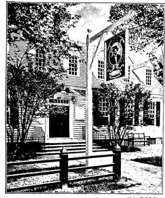
(phot. U.S.I.S.)
UNITED STATES (U.S.A.) – The Raleigh Tavern, bearing as its sign the portrait of the explorer Sir Walter Raleigh – Williamsburg (Virginia).
in the circum-Pacific belt, rainfall is more abundant and generally occurs in winter, but with a tendency to decrease again toward the S. (California). In general, the coastal countries here have a Mediterranean-type climate, milder and more uniform than those on the Atlantic, whose conditions, in turn, are in this respect less mild and more changeable than those of European countries at the same latitude. Moreover, the regions near the Atlantic are often devastated by the terrible cyclones that form in the Caribbean Sea and cross the West Indies, the western U.S.A., and the North Atlantic. Toward the S., along the Atlantic coast (Florida and the Gulf of Mexico), the climate takes on an increasingly distinct subtropical character, with intense heat and rather abundant precipitation.
The territory of the U.S.A. may thus be divided, from the physical-economic point of view, into four major units: in the N., E., and center, a temperate-humid region, with well-developed agriculture, especially cereal cultivation, and livestock raising; in the S., a subtropical region, producing cotton, rice, and tobacco; in the W., an arid region, in which, alongside livestock raising, cereal cultivation is nevertheless possible through artificial irrigation; and on the Pacific, a region of Mediterranean character, in which citrus fruits, vines, and fruit trees flourish above all. Each of these regions possesses mineral reserves in greater or lesser abundance. Yet the exploitation of these riches has not everywhere reached the same level, so that, despite the great impetus given to every kind of economic activity, especially as a result of the two last great world wars, the U.S.A. still retain, over fairly extensive areas, the appearance of a new country.
Moreover, mass colonization began rather late. At the time of discovery, the Indians living in the territory of the U.S.A. did not exceed one million, and the total population, which was approximately 3 million in 1776 (at the time of the proclamation of independence), had only slightly exceeded 23 million by 1853, when the metropolitan territory reached its present extent. But from
1820 to 1930 more than 37 million individuals immigrated to the U.S.A. (8 million in the decade 1900–11 alone), among whom at first the English, Scots, Irish, Germans, Scandinavians, and Finns predominated, and later Italians, Slavs, Jews, and Hungarians. According to the latest census (1950), the population amounts to 150.7 million inhabitants, of whom Negroes (numerous especially in the regions of the S. and SE.) constitute approximately 10%, Indians (reduced to only a few hundred thousand individuals) barely 2%, while a high percentage (impossible to calculate precisely) is represented by persons born abroad or by children of foreign parents (nearly 7 million Germans, 4 1/2 million Italians, more than 3 million Irish, and as many Poles and Canadians, etc.). The population density (19 per sq. km.) is rather low (only slightly higher than that of Sweden), but the differences from region to region are considerable: while the western uplands are almost uninhabited (less than 1 inhabitant per sq. km. in the State of Nevada), the Atlantic States have figures exceeding 200 inhabitants per sq. km. (Rhode Island, Nuova Jersey, Massachusetts). Taking into account the territories controlled by the U.S.A., their population rose (1951) to 155.4 million inhabitants, of whom 2.5 million were in America (2.2 in Puerto Rico) and 635,000 in Oceania.
As regards economic development (and, indeed, also from the political-military point of view), there is no doubt that the U.S.A. today represent the greatest world power. This is the consequence not only of the share allotted to them in the totality of natural resources of every kind, in a new country open, at least initially, to mass collaboration and permeated ab origine by an unlimited spirit of initiative, nor of the scale on which these resources have been exploitable, but also of a technical progress which general prosperity and the aspiration to individual gain have raised to an exceedingly high level, both average and absolute.
The tendency to achieve, in every form of activity, the maximum output with the minimum use of human labor, and therefore on the basis of rational planning that takes account of all the factors of production and stimulates it with the aid of increasingly widespread and efficient mechanization, is also visible in agriculture, which, despite the grandiose development of industry, remains one of the firmest foundations of the national economy. In 1950 agriculture absorbed only 17% of the working population (10% during the Second World War), but the 8.3 million persons employed used approximately 10 million motorized machines. Less than one-fifth of the territory of the United States is cultivated (and four-fifths of it in the eastern half of the country alone); nevertheless, the U.S.A. harvest, among other products, from 50 to 60% of the world’s corn, from one-fifth to one-third of its cotton, more than one-fourth of its tobacco, from one-fifth to one-fourth of its oats, and from one-sixth to one-seventh of the wheat produced throughout the world. More than half of the arable land (184.1 million ha.) is devoted to cereals and produces chiefly corn (from 35 million tons in 1934–38 to 79 in 1950; the corresponding figures will also be given below in millions of tons), followed, in descending order of quantities produced, by wheat (19.5–27.5), oats (14.0–21.5), barley (45–65.3), rice (9.6–17.2), and rye (10.3–5.7). While all the corn is consumed within the country, wheat permits a considerable export (6.5; the highest figure among all the world’s exporters in 1950).
Next in importance after cereals comes cotton, cultivated in the southeastern States (5.8–2.1 of fiber; 4.0–6.0 of seed): one-half of the fiber production and almost the entire production of seed (oil) are absorbed by the domestic market. Also noteworthy are the cultivation of soybeans (1.2–7.8) and flax (0.2–1). As regards tobacco, the U.S.A. lead both in production (0.6–0.9) and in world exports, whereas in the case of sugar, beet and cane production still fails to satisfy domestic consumption. Fruit growing has developed greatly (California, Florida, the Great Lakes region), supporting a flourishing industry; alongside citrus fruits, California produces grapes (16 million hl., as much as Spanish production in 1950), destined in part for wine-making. Because of intensive reforestation, forest production has declined; forests are now limited to the Pacific States (douglas fire) and Florida (pitchpine), but nevertheless they support substantial industries (paper, furniture), even though they are no longer sufficient for the domestic market.
Agriculture and livestock raising are closely linked: in terms of the number of animals (78.3 million; a figure surpassed only by India) and the importance of the industrial production connected with them, cattle come first, raised chiefly in the central States (meat) and northeastern States (milk), followed by swine (57.1; first place in the world), characteristic of the corn region, sheep (31.7), horses (6.0 horses; 2.3 mules), and goats (2.4). Fishing is also flourishing: in certain specialties (oysters, sardines, salmon), the U.S.A. hold one of the leading places, or even first place, in the world.
This solid agrarian structure, together with the ancillary activities that complement it, is accompanied by an even more imposing industrial expansion, whose possibilities appear practically unlimited, given the extraordinary abundance and variety of the mineral resources available to the U.S.A. First and foremost, energy-producing materials: coal (the U.S.A. extract more than one-third of the world quantity: 505 million tons in 1950, half of it from the Appalachian fields) and petroleum (270 million tons, 53% of the world total), to which must be added the hydroelectric resources, estimated at 45 million HP and yielding, in 1950, a production of 590 million HP (first place in the world).
In their industrial development, the U.S.A. leave all the other countries of the world far behind: there is no branch in which production has not established itself through the features that distinguish it—standardization, rationalization, mechanization, and the concentration of enterprises (trust), all of which have, to a greater or lesser extent, worldwide repercussions. Although certain branches of activity stand out above the others—for example, the metallurgical industries (steel: two-fifths of world production) and the mechanical industries (four-fifths of the automobiles and three-quarters of the typewriters manufactured throughout the world)—especially because of their localization in particular districts, their distribution throughout the vast metropolitan territory follows criteria of economic convenience that make it possible to meet, above all, the exceptional dimensions of the domestic market, which is another distinguishing feature of American industry. The result is a multiplicity of industrial regions, each of which possesses, or accentuates, its own distinctive character: iron and steel and metallurgical industries in the area near the Great Lakes; textile industries in the Middle Atlantic States; lumber industries in the northern and southern Atlantic States, around the Great Lakes, and along the Pacific; food industries almost everywhere, but especially in the north-central and northeastern States.
The gigantic industrial organization of the U.S.A. would be inconceivable without an adequate development of communications. The railways extend for more than 360,000 km (one-third of the world network), but they are now
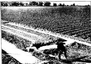
(photo U.S.I.S.)
STATI UNITI (U.S.A.) — View of a cultivation in Arizona.
in decline in the face of the expansion of motor transport, which has an imposing road network (5.3 million km.; 48 million motor vehicles, that is, approximately one for every 3 inhabitants, compared with one for every 70 in Italy), and of air transport, which is increasing very rapidly (738.7 million km travelled; 14.2 million passengers). Equally clear, after the Second World War, was the supremacy of the merchant navy, which in 1950 recorded no less than 25.2 million tons of mechanically propelled shipping, thereby surpassing Great Britain and representing by itself approximately one-third of the world total.
Characteristic of the U.S.A. today are the scale and the economic and political importance of urbanization; it may be estimated that approximately 60% of the population lives concentrated in cities, many of which have experienced extremely rapid geographical and demographic development. Of those exceeding 100,000 inhabitants (the so-called “large cities,” which in 1950 numbered 10 among the 876 existing throughout the world), there are now more than a dozen which, with or without their immediate surroundings (metropolitan districts), have by now exceeded 1 million inhabitants.
The distribution of the major urban centres, like that of the population in general, still shows an evident contrast between, on the one hand, the northeastern sector of the country, between the Atlantic and the Mississippi upstream from the confluence of the Ohio, and, on the other, the inland regions, in which large cities still constitute exceptional occurrences; while other urban concentrations undergoing certain expansion have arisen along the Pacific, both to the S. (California) and to the N. (between Puget Sound and the lower Columbia). These cities, all of more or less recent origin, are clearly distinguished from the old European urban centres by certain characteristics common to them and which make them all resemble one another: the extensive area of the city, in which parks, gardens, and public and private lawns occupy a large part; the regular form of the plan; the absence of walls and boundaries toward the outskirts; and the separation between the inner nucleus (City), or business district, dense with public buildings and monuments and crowned by skyscrapers, and the more extensive residential districts, where detached buildings predominate and large structures are seldom found. It should be noted that the capitals of the States do not as a rule coincide with the most populous, most active, or economically most important cities; at times such a function is performed by centres with a population of less than 10,000 inhabitants. The intention was thus to ensure that the centres chosen as seats of government would above all have a suitable position in relation to the territory of the individual States, as well as conditions of tranquillity and isolation, so that the administration of the States themselves would not be disturbed by business affairs, and the interests of a few or of a single city would not prevail over those shared in common. Nevertheless, with
TABLE 1.
| States and groups of States | Area in sq. km. | Population in thousands (1950 census) | Density per sq. km. | Capital (population in thousands) |
|---|---|---|---|---|
| Maine | 86017 | 913,8 | 11 | Augusta 71 |
| New Hampshire | 24095 | 533,2 | 22 | Concord 28 |
| Vermont | 24884 | 377,7 | 15 | Montpelier 8 |
| Massachusetts | 21383 | 4690,5 | 219 | Boston 791 |
| Rhode Island | 3144 | 791,9 | 252 | Providence 248 |
| Connecticut | 12972 | 2007,3 | 155 | Hartford 177 |
| NEW ENGLAND | 172.495 | 9314,5 | 54 | — |
| New York | 128387 | 14830,2 | 115 | Albany 134 |
| New Jersey | 20293 | 4835,3 | 238 | Trenton 128 |
| Pennsylvania | 117399 | 10498,0 | 89 | Harrisburg 89 |
| MIDDLE ATLANTIC | 266.079 | 30163,5 | 113 | — |
| Distr. Columbia | 179 | 802,2 | 4481 | Washington |
| Delaware | 5327 | 318,1 | 60 | Dover 6 |
| Maryland | 27391 | 2343,0 | 86 | Annapolis 15 |
| Virginia | 105699 | 3318,7 | 31 | Richmond 230 |
| West Virginia | 62622 | 2005,5 | 32 | Charleston 73 |
| North Carolina | 136508 | 4061,9 | 30 | Raleigh 5 |
| South Carolina | 80423 | 2117,0 | 39 | Columbia |
| Georgia | 152471 | 3444,6 | 23 | Atlanta 327 |
| Florida | 151653 | 2771,3 | 18 | Tallahassee 27 |
| SOUTH ATLANTIC | 722.273 | 21183,3 | 29 | — |
| Ohio | 106753 | 7946,6 | 74 | Columbus 375 |
| Indiana | 93983 | 3934,2 | 42 | Indianapolis 375 |
| Illinois | 146059 | 8712,2 | 60 | Springfield 81 |
| Michigan | 150762 | 6371,8 | 42 | Lansing 92 |
| Wisconsin | 145422 | 3434,6 | 23 | Madison 96 |
| EAST NORTH CENTRAL | 642.979 | 30399,4 | 47 | — |
| Minnesota | 217711 | 2982,5 | 14 | St. Paul 310 |
| Iowa | 145743 | 2621,1 | 18 | Des Moines 177 |
| Missouri | 180435 | 3954,7 | 22 | Jefferson City 25 |
| North Dakota | 183001 | 619,6 | 3 | Bismark 19 |
| South Dakota | 199529 | 652,7 | 3 | Pierre 4 |
| Nebraska | 200021 | 1325,5 | 7 | Lincoln 97 |
| Kansas | 213070 | 1905,3 | 9 | Topeka 78 |
| WEST NORTH CENTRAL | 1.339.515 | 14061,4 | 10 | — |
| Kentucky | 104611 | 2954,8 | 28 | Frankfort 11 |
| Tennessee | 109404 | 3291,7 | 30 | Nashville 173 |
| Alabama | 133652 | 3061,7 | 23 | Montgomery 105 |
| Mississippi | 123570 | 2178,9 | 18 | Jackson 98 |
| EAST SOUTH CENTRAL | 471.237 | 14477,2 | 31 | — |
| Arkansas | 137518 | 1909,5 | 14 | Little Rock 101 |
| Louisiana | 125660 | 2683,5 | 21 | Baton Rouge 124 |
| Oklahoma | 181069 | 2333,4 | 12 | Oklahoma City 242 |
| Texas | 692328 | 7711,2 | 11 | Austin 132 |
| WEST SOUTH CENTRAL | 1.136.575 | 14537,5 | 13 | — |
| Montana | 381043 | 591,0 | 2 | Helena 17 |
| Idaho | 216388 | 588,6 | 3 | Boise 34 |
| Wyoming | 253568 | 290,5 | 1 | Cheyenne 32 |
| Colorado | 269968 | 1325,1 | 5 | Denver 413 |
| New Mexico | 315078 | 681,2 | 2 | Santa Fé 28 |
| Utah | 219907 | 688,9 | 3 | Salt Lake City 182 |
| Arizona | 294990 | 749,6 | 3 | Phoenix 105 |
| Nevada | 286265 | 160,1 | 1 | Carson City 3 |
| MOUNTAIN | 2.257.207 | 5075,0 | 2 | — |
| Washington | 176597 | 2379,0 | 13 | Olympia 16 |
| Oregon | 251152 | 1521,3 | 6 | Salem 43 |
| California | 410967 | 10586,2 | 25 | Sacramento 136 |
| PACIFIC | 838716 | 14486,5 | 17 | — |
| U.S.A. | 7.827.076 | 150.697,4 | 19 | Washington 1498 |
| Name of possession (year of its recognition) | Area in sq. km. | Population (in thousands) | Density per sq. km. | Capital and its population (in thousands) |
|---|---|---|---|---|
| in America | ||||
| Alasca (1867) | 1.518.717 | 128,6 | 0,1 | Juneau 6 |
| Puerto Rico (1899) | 8.896 | 2.210,7 | 249 | S. Juan 224 |
| Canal Zone (1904) | 1.422 | 53,3 | 37 | Balboa 10 |
| Isole Vergini (1917) | 344 | 26,7 | 78 | Charlotte Amalie 11 |
| in Oceania | ||||
| Isole Hawaii (1898) | 16.772 | 499,8 | 30 | Honolulu 232 |
| Isola Guam (1899) | 534 | 58,8 | 110 | Agaña 10 |
| Isole Samoa americane (1900) | 197 | 18,6 | 96 | Pago Pago 1 |
| territories of the Pacific | ||||
| Islands (1947) | 2.149 | 50,0 | 23 | — |
| in the Antarctic | ||||
| U.S.A. sector | 1.800.000 | — | — | — |
| Total | 3.349.000 | 3.085,0 | 1 | — |
The U.S.A. are organized as a federal Republic; the States composing them differ greatly in size, population, and economic importance, in keeping with their history, their economic development, and the stages through which local and national evolution has passed. The average area of these States is approximately equal to that of half the Italian territory (163.3 thousand sq. km.); the average population is about 3.1 million inhabitants. But it is easy to see from the accompanying table how different these conditions are, not only from one State to another, but also from one group of States to another. A comparison with the data from the preceding censuses highlights the trend that has now become clearly apparent, toward an accentuation of the contrast between the periphery and the interior. The Atlantic States (especially Florida) and those on the Pacific (first and foremost California) are in fact growing above all, at the expense of the arid regions W. of the Mississippi, which constitute areas of emigration.
ethnic groups in american life, Nuova York 1935; G. I. Miller - A. E. Parkins, Geogr. of North Amer., there 1935; A. A. Michieli, Amer. del Nord, Milano 1935; H. Baulig, Amérique septentr., Parigi 1935; O. Maull, Die Vereinigten Staaten von Amer. als Grossreich: Länderkunde und Geopolitik, Berlino 1940; W. W. Atwood, The physiogr. provinces of North Amer., Boston 1940; H. Hull Mc Carty, The geogr. basis of Amer. life, Nuova York-Boston 1940; J. Russell Smith - M. Ogden Philips, North Amer.: its people and its resources. Development and prospect of the Continent as home of man, Nuova York 1942; G. Langdon White - E. J. Foscue, Regional geogr. of Anglo-Amer., there 1943; G. M. Myrdal, An american dilemma: The Negro problem and modern democracy, there 1944; G. Gozen, The Americans, Nuova York-Londra 1948; E. F. Frazier, The Negro in the U. S., Nuova York 1949. Giuseppe Caraci
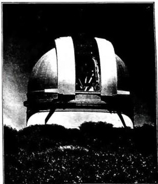
(Int. U.S.I.S.)
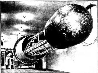
UNITED STATES (U.S.A.) - Observation dome of the Mount Palomar Observatory.
(Ist. U.S.I.S.)
STATI UNITI (U.S.A.) - Generatore elettrostatico, usato nella ricerca dell'energia atomica all'Università di Notre Dame.
II. CIVIL HISTORY
1. The Colonial Period
Henry VII, basing his claims on the voyages undertaken by the Cabots in his service, had asserted England’s right to the continent where the United States would arise as early as 1497. However, it was only under the reign of Elizabeth, particularly after the defeat of the Spanish Armada (1588)—which opened the seas to English supremacy—that English merchants and adventurers undertook the first, unsuccessful attempts at colonization. Meanwhile, the Dutch established colonies in New Netherland, the Spanish in Florida, and the French in the region of the Great Lakes and the St. Lawrence.According to English law, the entire claimed territory belonged to the Crown, which could dispose of it at will. In its grants, the Crown created two types of colonies: corporate (i.e., granted to a company) and proprietary (granted to an individual), leaving the beneficiaries broad autonomy in the exercise of power and guaranteeing colonists the traditional rights of English citizens. Among these, though limited by many restrictions, the right to self-government was fundamental. From the founding of Virginia (1607), the first colony, until 1733, thirteen colonies arose along the Atlantic coast. Eight of these later became royal provinces, with governors appointed by the sovereign and possessing extensive powers. However, conflicts between constituted authority and the populations were frequent. The colonists played an active role in the local and central administrations of their respective territories, but it was England’s prerogative to regulate relations among them and with foreign countries. Nevertheless, the numerous wars of the time and the need for defense against the Indian tribes, which represented a constant threat, helped create a certain solidarity among the different provinces.
Waves of immigration, increasingly frequent and numerous, of diverse origins and driven by multiple reasons (political and religious persecutions, economic hardship and the promise of a better future, the spirit of adventure), gave the population a composite and heterogeneous character. However, the predominant—and, one might say, catalytic—element, especially after 1660, was the English. After the Peace of Paris (1763), which ended the long conflict between France and England, sanctioning English dominance over Canada and the Mississippi Valley, English expansion in the New World encountered no obstacles and was further spurred by the Industrial Revolution, which, by creating a problem of overpopulation in the mother country, encouraged emigration. By the end of the 18th century, three ethnic groups were the most numerous after the English: the Irish, the Scottish, and the Germans. Following them were the Dutch and Swedes (descendants of dissolved colonial empires) and the French.
2. Independence
In the second half of the century, relations between England and the colonies grew tense. With the treasury depleted by recent wars, the English government adopted a series of laws aimed at replenishing it at the colonies’ expense. The colonists received these tax impositions with increasing resentment, invoking the English custom that any fiscal measure had to be voted on by the taxpayers themselves. Relying on their long-standing traditions of autonomy and freedom, strengthened by the difficulties of exercising power due to the mother country’s distance, the colonists appealed to these traditions, accusing the Crown and Parliament of seeking to overturn the secular foundations of the Anglo-Saxon political order. Largely due to George III’s intransigence, the conflict worsened, and the thirteen colonies, choosing the path of open rebellion, declared their independence (1776), formed a confederation (1777), and fought a long and arduous war. Though it began poorly for the insurgents, after shifting fortunes, it concluded in their favor, thanks to the tenacity and skill of General George Washington, with the Peace of Paris (1783).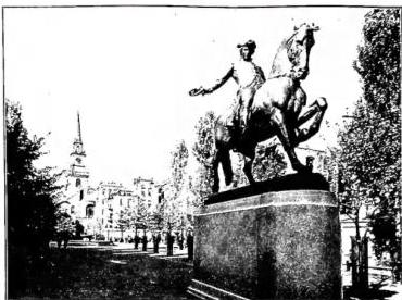
3. Continental Expansion. - The capital, after a brief tenure in New York and Philadelphia, was transferred to Washington, while expansion toward the West proceeded unceasingly, constituting the "epic" of American history and the salient event in the decades following the War of Independence. As pioneers, adventurers, and colonizers brought new territories under civilization, these came under federal control until, once certain requirements were met (they had to have a minimum of 60,000 inhabitants, a constitution, a legislative body, etc.), they were admitted into the Confederation as States. In the period from 1791 to 1821, eleven more States were thus added to the original thirteen. This progressive expansion led to countless and bloody conflicts with the Indians, until the survivors of that proud people were completely subjugated. Meanwhile, the Americans, intolerant of the presence of other governments on the continent, purchased Louisiana from Napoleon in 1803 and in 1819 expelled Spain from Florida. Instead, the attempt at expansion toward Canada, undertaken in 1812 for reasons of national prestige (which England had wounded by arrogating to itself the right to inspect American shipping), was unsuccessful. British naval supremacy, especially after Napoleon's defeat, prevailed, and with the Peace of Ghent (1814), which concluded the war, Canada remained a British possession.
During the subsequent period of peace and prosperity, new States were established; commerce and especially industries experienced great development, favored by the wars that had hindered the importation of European products and later by the adoption of high protective tariffs. Having proclaimed, with the Monroe Doctrine (v. DOTTRINA DI), isolationism and the absolute independence of the New World from Europe, the U.S. consolidated their unity and federal bonds, despite state particularisms, thanks to the authoritative expansive interpretations of the powers of the federal government, sanctioned by the Constitution and upheld for over three decades by John Marshall, Chief Justice of the Supreme Court.
4. The Civil War. - A latent conflict, however, was emerging in all its gravity. While in the Northern States slavery, never very widespread, was dying out naturally, in the Southern States it had become the pillar of the agricultural economy, which rested precisely on the very low cost of labor and its total servitude. The slaves were Blacks imported from Africa as early as 1619; by 1770 they amounted to one-sixth of the population. In the matter of slavery, the federal government could not intervene in any way, since the Constitution made no mention of it, and to abolish it throughout the territory, as the abolitionists demanded, a constitutional amendment was required, approved by a two-thirds majority, while the slave and anti-slave States were balanced, despite the efforts made by each side to prevail. The Ohio River marked the dividing line between the two types of civilization, and for every State that entered the Union north of the river, a new State was added to the south. When in 1820 Missouri, a slave territory, entered the Confederation, to balance its admission, part of Massachusetts was carved out to form the small State of Maine. Furthermore, a parallel was established as a dividing line for the vast territory still open to westward expansion (Missouri Compromise). This expedient postponed the solution of the problem for several decades, while new pioneers penetrated Spanish Texas and settled along the Pacific coast.
After the long predominance of the Jeffersonian party, political struggles resumed, first on a regional basis and later along party lines. Republicans
Equestrian monument to Paul Revere, patriot of the American War of Independence (1775-83). In the background, the old church where the lantern is preserved that gave the signal for Paul Revere’s ride—Boston.
The industrial policy of the Republicans, once in power, harmed the Southern States, which reacted by succeeding in electing Andrew Jackson to the presidency. Disregarding the will of Congress and considering himself the direct representative of the people, he established the practice of reserving public offices, both major and minor, for his own supporters (spoils system). During his presidency, the first labor organizations emerged, the right to vote was democratically extended in all types of elections, and suffrage for presidential elections was broadened; this led to the appearance of true political professionals. Jackson deserves credit for defending the inviolability of the Union, crushing in a historic conflict the secessionist ambitions of one State, South Carolina, which, opposed to a new federal tariff law, threatened the country’s unity. With the rapid opening of new communication routes and the introduction of faster means of transport, economic progress seemed to know no bounds.
The annexation of Texas, desired by the slaveholding States for the possibility of vast plantation agriculture in that territory, led to war with Mexico (1846-47), which ended with the conquest of new regions (New Mexico, Arizona, California), while by virtue of an agreement with England, Oregon was annexed. By 1848, therefore, the Confederation had reached its current continental borders, and to secure an inter-oceanic communication route, it had already in 1846 concluded an agreement with Colombia for free passage through the Isthmus of Panama.
The acquisition of new territories revived the question of slavery. California, having adopted an anti-slavery constitution, requested admission to the Confederation (1849), provoking protests from the South. A new compromise allowed its admission (1850), stipulating that in the new States that might arise from the territories taken from Mexico, slavery could not be prohibited or abolished. However, since—apart from Texas—none of those territories was suited to a slave-based economy, their entry into the Confederation as States would have given the anti-slavery States a majority, enabling them to pass the necessary abolitionist amendment and suppress slavery throughout the U.S. For
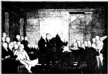
STATI UNITI (U.S.A.) - The Congress Votes for Independence, painting by R. Edgar Pine and E. Savage (late 18th-early 19th century) - Washington, Library of Congress.
To restore the balance, the Southern states attempted various coups in lands suited to their economy (Cuba, Nicaragua, Honduras). But while the abolitionists fought their battle on ethical grounds, and their cause, in continuous progress, acquired the force of a categorical imperative, the slaveholders appealed to practical reasons, namely the staggering demographic growth of Blacks, who in some states outnumbered whites, and above all to the necessary defense of the Southern economy, which abolitionism would have dealt a mortal blow. Thus, after 1850, the conflict became open and intransigent, and the slaveholders, seeing their cause endangered by the firmness of the Northerners, went on the offensive. In 1854, they obtained from Congress the abolition of the Missouri Compromise, leaving new territories (Nebraska and Kansas) free to adopt slavery or not. The resulting indignation in the North led to the formation of a new Republican Party, which rose to power in 1860 LINCOLN, A (v.). After his election, the Southern states precipitated events: seven of them proceeded to form a new Confederation. Faced with Lincoln's decision to preserve the Union, war became inevitable. The North, rich in industries, though it controlled the fleet, was nevertheless less militarily prepared; the South, on the other hand, vainly counted on English and French intervention. By sanctioning the liberation of slaves on January 1, 1863, Lincoln gave the war the character of a crusade that excluded any compromise. The Battle of Gettysburg (1863) turned events in favor of the Northerners, who in 1865 completed the occupation of the Southern states, just as Lincoln was assassinated by a Southerner. The President's death, who had shown both firmness and moderation, led to an ill-advised policy against the vanquished, to whom, along with the abolition of slavery, a series of humiliations was imposed that exasperated them. Martial law was necessary to enforce the so-called Reconstruction of the South, that is, its re-entry into the Confederation, which in reality became an occasion for exploitation by adventurers descending from the North. The South sought to defend itself by creating secret associations, such as the Ku Klux Klan, which aimed to keep Blacks in subjection. Over time, hatreds and resentments diminished, but a period of general pacification could only begin in 1877, with the presidency of Hayes, during which the South regained full rights. This, however, did not resolve the problem of coexistence between the two races, still open and burning. Whites maneuvered in their favor by promoting state legislation that greatly reduced the scope of the constitutional amendments and practically deprived Blacks of all political freedom. Added to this were the aforementioned systems of intimidation, which together served to keep Blacks, until the present, in conditions of minority.
5. The Rise of Imperialism. - During 24 years of Republican administration, despite many errors, the country had overcome the crisis of a civil war, had expanded relentlessly at the expense of Indian tribes, now confined to special federal reserves; had acquired Alaska from Russia for a sum of money; had given enormous impetus to industries and agriculture, which was also becoming industrialized; had welcomed ever greater and more frequent waves of immigrants arriving from Europe to populate the great cities and the vast expanses open to exploitation. The government passed to the Democrats with the election of Cleveland as president (1885-89). The country, entirely absorbed in its own development, was completely estranged from the rest of the world and seemed to have no foreign policy problems. The large industrial interests, whose expansion was favored by the country's vast resources but which led to frequent conflicts with agricultural and labor classes, began to exert an influence on the political level that was to grow and extend over time; while unions resorted to even violent demonstrations—particularly serious were the riots in Pittsburgh in 1877 and in Chicago in 1894—to assert labor rights and protest against big industry, which, among other things, tended to use low-cost labor imported directly from Europe, to the detriment of American workers.
The issue of protective tariffs, desired by industrial interests, brought the Republicans back to power, which they retained for 16 years. On the other hand, it became increasingly difficult to distinguish and differentiate the programs of the two parties, which seemed to be inspired by pragmatism and empiricism rather than by precise and clearly definable ideologies. With the Republicans, the nascent imperialist movement gained great momentum, which under the banner of the so-called manifest destiny led to the war with Spain over Cuba (1898), desired by the U.S.A. to dominate economically and militarily the Gulf of Mexico and Central America, a war resolved in four months; it led to the acquisition from Spain of the Philippine Islands and the annexation of Puerto Rico as a colonial territory; and to ever greater interference in the affairs of the Far East, where the U.S.A. intervened against the Boxers and later championed the policy of the "open door"; and finally to the impetus given to the construction of a fleet. The push beyond continental borders was favored by the end of the "frontier," the mobile line of demarcation between colonized territory and virgin land, so that the expansionist drive turned outward, translating into imperialism and materializing, among other things, in the convening of a Pan-American conference (1889; V. PANAMERICANISMO). The U.S.A. took the lead, aiming to secure a position of economic hegemony over Latin America and accompanying diplomatic action with a policy of force, which resulted in the conquest of various islands, including Hawaii. Theodore Roosevelt, who came to power at the beginning of the new century, vigorously pursued this policy in Central America. Having approved the construction of a canal through the Isthmus of Panama, and seeing that Colombia was temporizing and seemed to resist American pressure, the proclamation of the Republic of Panama was favored, which in fact became an American protectorate. The U.S.A. began to make their influence felt in international politics, mediating the conflict between Russia and Japan (1905). The authority of the federal government was extended, which promoted legislation on trusts, on immigration—which was beginning to cause concern due to its vast scale—and on other matters that marked the country's entry onto the world stage.